Offroad routes
Who may drive where on Forest Service and BLM land.
USFS MVUM · BLM
For iPhone
Record the route you walk, run, ride or drive. Yut draws it on the map as you go — with the phone locked, in your pocket, even after iOS closes the app.
16map styles, from USGS Topo to satellite
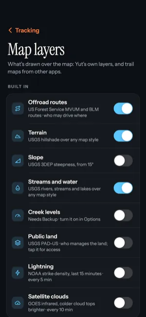
9built-in map layers, from public land to live lightning, plus your own trail maps
6themes, four dark and two light
No ads,no analytics, no account
Map layers
Lay government map data over any of 16 map styles: who may drive which forest road, how steep the next climb is, whose land you're on, whether the creek is rising and where lightning just struck. Every layer is off until you want it.
Hatfield–McCoy
Load the official Hatfield–McCoy trail inventory file as a layer and Yut shows the official trail map: every trail's number, name and difficulty, the trailheads, the towns and the system dividers. Yut will never charge for it.
A Hatfield–McCoy trail permit is still required to ride.
Who may drive where on Forest Service and BLM land.
USFS MVUM · BLM
Shaded relief, and every slope of 15° and steeper.
USGS · 3DEP
Rivers, streams and lakes; creek gauges rising or falling with Backup (invite-only).
USGS NHD · Water Data
Who manages the land under you. Tap it for access.
USGS PAD-US
Strikes in the last 15 minutes, refreshed every five.
NOAA nowCOAST
Weather radar, current conditions and infrared clouds.
NEXRAD · GOES
Fire detections from the last 24 hours, with Backup (invite-only).
NASA FIRMS
Import the trail maps you already have, one legend for all.
GPX · KML · KMZ · GeoJSON · BCN · MPZ
Set your vehicle and the imported trails it may not use are drawn faded, so the routes that are yours to ride stand out at a glance.
Record
Tap Start and put the phone away. Yut keeps recording in the background and on the Lock Screen. If iOS closes the app on a long day, it picks up where it left off the next time you open it — and fills in what it can of the miles it missed.
Reopen the app and the route comes back, gaps backfilled.
Inaccurate and impossible GPS jumps are thrown out before they count.
Where GPS went quiet, the line turns dashed. No guessing.
A fix a second, or a lighter touch for an all-day ride.
History
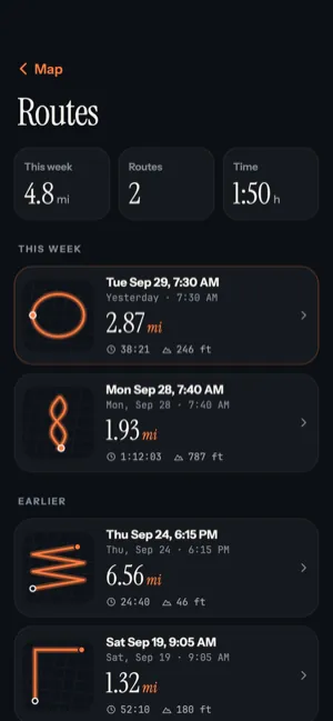
Name your routes, see your week at a glance and open any one on its own map with the full story of how it went.
Live Activity
The route's outline, distance and time sit on your Lock Screen and in the Dynamic Island, so you never have to unlock to check. It's all worked out on the phone — no push, no server.
Themes
Each theme colours the whole app — the route, your location dot, the Live Activity — and picks a map style to match. Choose one in Tracking options, under Appearance.
Privacy
Your routes are saved on your iPhone and stay there. No account, no ads, no analytics. Here's everything that ever leaves the phone, and when.
Stays on your phone
Saved on the device as you record. Routes go nowhere unless you turn on Backup; pins and imported trails never leave the phone.
Only what the map needs
The area on screen goes to the map's provider. Weather sees your location rounded to about a kilometre.
Only if you choose
Optional and invite-only. Your routes, the links you share and the app's diagnostics go to Yut's server. Restore your routes on a new phone, or delete them from the server any time.

Yut is for iPhone. No account, nothing to sign up for — install it and press Start.

